Historical Maps of Moskitia
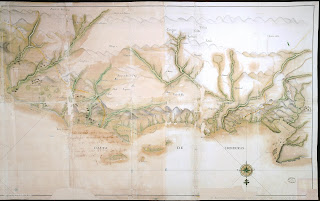
Razon de los establecimientos que hay desde el escudo de Veraguas hasta Onduras, 2 de Septiembre de 1777.
Map of the Mosquito Shore From real observation and remarks by David Lamb. The interior by John Christopher, 1780.
Carta Ydografa de la Costa de Mosquitos e Yslas Adiacentes, 1793.
Map of the several proposed routes for Ship Canal Communication between the Atlantic and Pacific Oceans.
Mexico and Guatemala, shewing the Position of the Mines,
Mexico and Guatemala, shewing the Position of the Mines,


.jpg)


_it_and_Iamaica_LOC_2004627358.jpg)

.jpg)


.jpg)


.jpg)


_Mexico_The_British_Possessions_In_North_America_And_The_United_States%20(1).jpg)


.jpg)


Comments